The Last-Mile Access Problem
Last-mile Access refers to the ability to move freight between mainline transportation corridors (including Interstate highways) and local facilities, including manufacturing plants, warehouse/distribution centers, medical facilities, retail or restaurants, and other freight generators. For example, trucks shipping goods from a factory may need to drive on local “last mile” streets to reach a major highway, and food delivery trucks may have to find a route to navigate from an interstate highway to local restaurants via an arterial street. Dray trucks carrying containers may pass through neighborhoods as they leave the highway and make their way to a port. The term last mile is a notional description – in reality, the lengths of local routes can often be over ten miles long!
Last-mile shipments are often the least efficient leg of a freight trip, because of inefficient access to hubs or points of delivery.”
Last mile access challenges can be broken down into two categories: facility access challenges near major freight hubs, like intermodal terminals, factories, and distribution centers, and arterial management challenges through signalized arterials and non-highway corridors with chokepoints such as bridges, ramps and railway crossings (Pierce, 2013). Both types of access problems result in congestion and hazards, with the associated lost productivity, increased pollution, and decreased the quality of life.
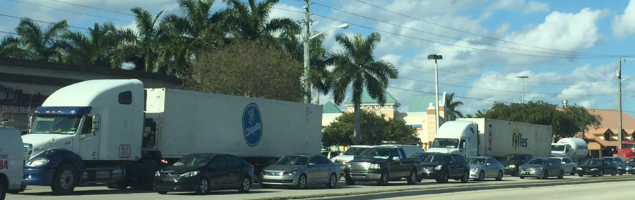
Facility Access Challenges: Problems associated with last-mile access to freight hubs are often related to the large amounts of truck traffic the hubs generate. For these hubs, access problems include long queues to enter facilities, inadequate highway on- and off-ramps, incompatible freight corridor uses (like the presence of bike lanes on truck routes), or poorly-placed entrances and exits, requiring trucks to take circuitous routes. As shown in the figure, trucks encounter difficult turns and circuitous routes while trying to access freight facilities, especially near busy intersections where wide turns and navigating traffic might be required. These hub access problems may be a result of poorly designed infrastructure, or of poor freight and land use coordination. This challenge can be addressed by enhancing operations and planning to improve routing for more direct access to freight facilities, and by considering options to provide safe and efficient ingress/egress.
Trucks waiting at a busy intersection to access a nearby freight facility
Arterial Management Challenges: Arterial roads, the intermediate high capacity roads that link highways and local streets, present additional challenges for freight due to mistimed signal operations, and the lack of coordination of signal operations across multiple jurisdictions. The most relevant observed challenges during traffic operations that create frictions for the safe and efficient movement of trucks and their interactions with other traffic modes are:
- Long truck wait times at busy signalized intersections to access/leave freight facilities.
- Frequent stops and starts, accelerations and decelerations.
- Wide or difficult turns that create traffic slowdowns, especially during peak travel periods.
- Queuing on or near ramps to enter signalized arteries, facilities, or near railway crossings.
- Potential conflicts and interactions with other vehicle types, including cars, bicycles, or trains at crossings.
According to the Federal Highway Administration, there are more than 330,000 traffic signals operating in in the US. Most agencies retime signals on a 3- to 5–year cycle at a cost of about $4,500 per intersection unless there are signal-related malfunctions, failures or incidents, or dramatic changes in traffic patterns (Federal Highway Administration, 2017).
In the absence of real-time data about the need for retiming or maintenance, and given the prohibitive cost of manually collected traffic data to frequently update signal timing, retiming and signal maintenance schedules are based on models and simulations.
Further, many agencies use between three to seven signal timing plans per day and different plans for weekends, and the choice of plan may not be calibrated or updated to coordinate with real-time traffic conditions (Transportation Research Board, 2010).
The benefits of optimizing traffic flows through frequent retiming, re-phasing, and advanced signal control are well documented (Transportation Research Board, 2010; Federal Highway Administration, 2015). For example, retiming 215 signals in the Washington, D.C. suburbs reduced average arterial delay by 94%, and reduced arterial stops by 77% (Sunkari, 2004). A barrier to signal optimization is inter-jurisdictional coordination. About 80% of traffic signals in the US are managed, operated, and maintained by local agencies, and signal operations may not be coordinated between various local agencies on a road corridor or in a region (Federal Highway Administration, 2009).
The common thread linking many of these challenges is the lack of an operations feedback loop between field conditions and a traffic management center. For example, decision-makers may not have access to freight traffic behavior at granular time intervals or high-resolution understanding of activity at chokepoints such as railway crossings. In other cases, they may not be able to update operations decisions such as signal timing, control, or information-based to notifications to drivers to influence their behavior (speed, routes, etc.) in real time.
Anticipating the increasing connectedness and automated communications ability of vehicles with embedded sensors (Vehicle-to-Infrastructure and Infrastructure-to-Vehicle communications), real-time arterial management such as Adaptive Signal Control (ASC) and Freight Signal Prioritization (FSP) approaches are now closer to reality. The final report for NCHRP 20-102(03), Challenges to CV and AV Applications in Truck Freight Operations, suggests that:
“Once automated freight becomes a reality large amounts of data will be available…therefore there is a need to prepare and plan for managing and processing huge data sets that will be coming from CV and AV enabled trucks in order to increase their usefulness for planning and operations needs as we transition from the age of data scarcity to data abundance.”