• Skip to main content
  • Skip to primary sidebar

Understanding and Using New Data Sources to Address Urban and Metropolitan Freight Challenges

National Cooperative Freight Research Program (NCFRP) Project 49

  • Urban and Metropolitan Challenges
    • Congestion
    • Last-Mile Access
    • Final 50-feet Access
    • Land Use
    • Truck Parking
    • Case Studies
  • Emerging Data Sources
    • GNSS/GPS
    • Radar
    • Wireless Address Matching
    • Administrative Records
    • Cellular/GSM
    • Induction Loops
    • LIDAR
    • Computer Vision
  • Analytical Approaches
    • Speed
    • Location
    • Re-identification
    • Classification
  • Stewardship Principles
    • Transparency and Openness
    • Purpose Specification
    • Data Minimization
    • Data Quality and Accuracy
    • Accountability
    • Security
    • Data Management
  • Resources
    • Source Use Concept Map
    • Case Studies
    • Previous NCFRP Projects
    • Glossary
    • Sources Cited
Home » Emerging Data Sources Overview and Descriptions » High-Precision Global Navigation Satellite Systems (GNSS)

High-Precision Global Navigation Satellite Systems (GNSS)

Value Proposition – Truck GPS Data
What is the data source?
GNSS stands for Global Navigation Satellite System, and is an umbrella term that encompasses all global satellite positioning systems. The Global Positioning System (GPS) is one component of the GNSS. The NAVSTAR GPS is a constellation of satellites developed by the DOD in 1978 for military use, but later made accessible for civilian use (NASA, 2012). The 24 satellite system became fully operational in 1993. GPS currently provides two levels of service: Standard Positioning Service (SPS) which uses the coarse acquisition and Precise Positioning Service (PPS). Access to the PPS is restricted to US Armed Forces, US Federal agencies, and selected allied armed forces and governments. The SPS is available to all users on a continuous, worldwide basis, free of any direct user charges. GPS is now the most widely used GNSS in the world, and provides continuous positioning and timing information globally, under any weather conditions. GNSS is used in collaboration with GPS systems to provide more precise location positioning. GNSS and GPS work together, but the main difference between GPS and GNSS is that GNSS-compatible equipment can use navigational satellites from other networks beyond the GPS system, and more satellites means increased receiver accuracy and reliability.
What challenges do the data address?
GPS vehicle data can provide real-time measures of travel speeds and vehicle locations on the road network from which origin-destination information can be derived (Obahuma and Morturi, 2012; BITRE 2014). Data from multiple vehicles can reveal common OD points, and infrastructure bottlenecks. The derived information can be used to address congestion challenges.
Why is it new?
The technology is not new; however, the rapid uptake of GPS technology in fleet and other vehicles in the last 12 years has generated increased interest in applying the information in new ways to understand truck movements. Collecting and analyzing GPS data from trucks has historically been difficult for transportation planners and researchers. Many truck fleets currently produce GPS data, but their prime use for these data is to facilitate “real time” tracking and fleet management (Zmud et al, 2014). There are limited examples of using these data for truck observability. As a result, there are inadequate systems in place for data extraction and manipulation. It has been easier in some cases for agencies to buy the data from private sector providers who facilitate the collection of data for truck fleet management.
How are the data captured?
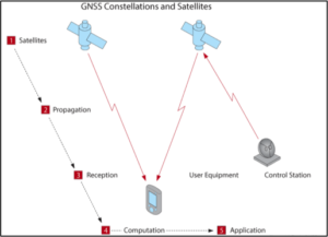
Basic GNSS systems geo-locate a user device in five operational steps, illustrated in the figure.

  1. Satellites: GNSS satellites orbit the earth in precise orbits closely monitored by ground-based control stations that adjust satellite paths and onboard atomic clocks.
  2. Propagation: GNSS satellites regularly broadcast precise location, time, status, and error adjustment information.
  3. Reception: GNSS user equipment receive transmitted information packets from four or more satellites.
  4. Computation: GNSS user equipment triangulates location by comparing time and position of satellite data, adjusting for errors as possible.
  5. Application: GNSS user equipment provides the computed position and time to the end user application, for example, navigation, surveying or mapping.

The GPS device movement creates a series of time-stamped coordinates, which can be used to derive various attributes, infer trip ends, and finally construct O-D information.

What are policy considerations in its use?
Since the 1980s, the U.S. has had stable and transparent federal policy regarding use of GPS and its management as a national asset (GPS.Gov, no date). The bulk of the funding for the national federal GPS program is provided by DOD, but the Department of Transportation also contributes funding to support civilian uses.

Several U.S. states and non-U.S. jurisdictions have enacted laws establishing personal location privacy rights. However, current U.S. statute at the federal level does not provide clear protection of geolocation information. Members of Congress have proposed legislation to prevent misuse of such information by law enforcement, companies, and individuals. These include the Geolocation Privacy and Surveillance Act (“GPS Act”), the Online Communications and Geolocation Protection Act, and the Location Privacy Protection Act. As of October 2017, none of these bills has been enacted into law. Another evolving area is the right of the federal, state and local regulatory agencies to collect, retain, use and disseminate electronic location data recorded and maintained by companies in their business operations. In the trucking industry, the Federal Highway Administration (FHWA) has initiated a pilot project that allows participating motor carriers to voluntary use GPS tracking systems to monitor compliance with the hours-of-service (HOS) requirements of the Federal Motor Carriers Safety Regulations and exempt drivers from maintaining paper logs.

Ownership falls into two categories (Hard et al, 2016): Public and private sector ownership. Public agency ownership where the agency collects primary GPS Data. Primary GPS data are raw, unprocessed GPS data collected through first-hand means such as using GPS tracking devices in vehicles to obtain travel-time data. Few agencies collect primary GPS data. Private sector GPS Data. There are two types of private sector data sources. Third party providers, such as HERE, TomTom, INRIX, or StreetLight, continuously collect, purchase, and compile GPS data from a variety of sources for eventual sale to businesses or government agencies. These data can be expensive to procure. GPS data acquired from these third-party providers will be pre-processed to anonymize it and/or to provide it in pre-established formats and outputs. The scale at which the anonymization and aggregation happens is a critical consideration, too much detail could raise privacy concerns, but too much aggregation could restrict the data utility. The second type are companies that generate GPS data (such as trucking fleets) but hesitate to monetize and share it. Public-private sharing agreement which are mutually beneficial may be necessary to gain access to this second type of private sector data.

What are institutional considerations in its use?
Public agencies often lack capacity to extract value from GPS/GNSS data in two crucial ways: skilled personnel, data infrastructure, and cross-agency collaboration. Most of the GPS data sets fall in the realm of big data, which requires a different set of skills and data infrastructure than traditional data collection and analysis. The secure storage and management of large data sets require substantial investment in the necessary data infrastructure such as servers/cloud storage. The effective use of GPS data sets often requires strong cross-agency collaboration, including the ability to scale costs across multiple budgets. This can run counter to the independent functioning of many agencies related to the built environment.

To fully extract value from high-resolution GPS / GNSS data and be able to verify its completeness, transportation agencies need a way to streamline the storage of large data sets and develop capabilities to analyze and visualize these data to inform performance measures. Many of these routines are automated using GIS and other analytical software, and decision-makers can rely on visual dashboards. Agencies interested in minimizing hardware, software, IT, and analytics capabilities can subscribe to services from specialist vendors.

There are GPS trace data is likely be more intensively employed by certain classes of road users, such data may not provide a representative OD sample suitable for more general use.

What are technical considerations in its use?
In terms of completeness of the resulting data, GPS sample penetration has improved in recent years due to more widespread use of GPS-enabled mobile devices, navigational apps, and in-vehicle navigation systems. Currently, TTI researchers estimate the GPS sampling rate from third-party data providers to be in the range of about 0.5 percent to 2 percent of vehicles on the roadways (Hard et al, 2016). However, this rate is continually increasing. GPS/GNSS data have been thoroughly vetted as it has been available for several decades. Early data accuracy and precision issues have been mostly solved. Still all GNSS technologies require a relatively clear line-of-sight between satellites and receiving antennas. Buildings, overpasses, and tunnels degrade or block entirely satellite transmissions. Densely developed urban areas are especially problematic due to the urban canyon created between tall structures blocking or reflecting signal, causing poor location accuracy or multipath interference. High precision applications such as the last-50-foot problems may suffer from location accuracy issues from built environments that block line-of-sight to multiple satellite feeds, lowering locational precision. Trip data from GPS data providers can be developed and extracted for almost any time period since the data collection frequency for GPS data can be as high as one second increments. However, third-party GPS data vendors will probably not provide trip flow data in increments of seconds because they would be unable retain proper anonymity of the data. The third party providers should also be able to provide the provenance of the data – percentage distribution based on type of devices capturing the data.

Primary Sidebar

  • GNSS/GPS
  • Radar
  • Wireless Address Matching
  • Administrative Records
  • Cellular/GSM
  • Induction Loops
  • LIDAR
  • Computer Vision
Assessment of Challenges in Data Use

These ratings are depicted using green, yellow, and red, where green indicates ease of use of the data source, yellow indicates some hindrance in use, and red indicates difficult to use.

Policy Considerations
Regulatory Environment
Ownership
Privacy
Institutional Considerations
Capacity
Stewardship
Equity
Technical Considerations
Completeness
Accuracy
Verifiability
Dynamism
Durability
Definitions – Policy, Institutional and Technical Challenges

Copyright 2019, National Academy of Sciences. All rights reserved.