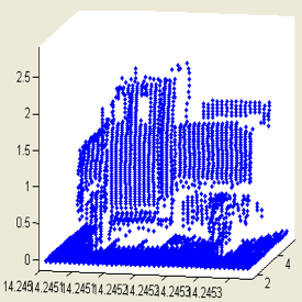
There are three types of LiDAR hardware: aerial LiDAR, stationary surveying LiDAR, and mobile LiDAR (Davis, 2016).
- Aerial LiDAR is the use of airborne LiDAR scanners mounted on aircraft to characterize the surface of the earth. The most common use is the generation of digital terrain models for elevation; however, it can also be used to collect data about man-made objects such as buildings, roads, or traffic flow on roads. The systems used for aerial LiDAR generally combine LiDAR scanning technology, which provides information about the geometry of the ground, with positioning instruments such as Global Navigation Satellite Systems/Global Positioning System (GNSS/GPS), inertial measurement units (IMUs), or other positioning technology to determine the position and path of the airplane. This technique is the least commonly used of the LiDAR approaches for freight traffic data collection.
- Stationary LiDAR systems are mounted on a base and slowly move to scan the area around it creating high accuracy, information-rich point clouds. These types of systems have many applications including traffic data collection, tolling, surveying and construction, forestry and agriculture, among others. Deployment of stationary LiDAR is easy, especially if the sensor is mounted on a vehicle that can be parked near the fixed point of data collection.
- Mobile LiDAR is the use of LiDAR technology on terrestrial vehicles. It is used to capture information about a vehicle’s surroundings including the road geometry, roadside obstacles, other vehicles, and more. This data can be used in many different ways from creating maps to real-time use in autonomous vehicle systems. Mobile LiDAR captures information about a corridor that is more detailed than aerial LiDAR but is faster to collect than setting up multiple scans with a stationary LiDAR product.

- Regulatory Environment: Facilitates data access and use.
- Ownership: Not tightly controlled.
- Privacy: Current applications typically protect private information
There are no specific regulatory or privacy issues to be addressed with LiDAR technology. The captured data are not directly associated with any specific user. More than likely the sensors would be owned and deployed by the public agency so that data ownership should not be a concern.
- Capacity: Fairly easy to work with data.
- Stewardship: Captures large amounts of data that complicates data storage and management.
- Equity: Data representative of specific roadway users.
The deployment and use of LiDAR technology is not complicated. Most over-roadway sensors are compact and not roadway invasive, making installation and maintenance relatively easy. The cost of LiDAR sensors has been decreasing rapidly with the growing market for small and cost-effective sensors for automated vehicle purposes. Data stewardship is more onerous than for radar systems because LiDAR they produce a large amount of data, which can be unwieldy and require careful data management practices (Olsen, et al 2013).
Because LiDAR maps the environment in three dimensions, multiple times per second, and at a high resolution, these sensors can generate a large amount of data very quickly. If an organization wishes to store and use LiDAR data, the entity should develop data management practices to help manage and make sense of the large volume of data.
- Completeness: Data gaps exist due to functionality issues.
- Accuracy: Limitations due to functionality issues.
- Verifiability: Access to raw data but data is voluminous presenting verification challenges.
- Dynamism: Time from capture to analysis is lengthened due to enormity of data processing requirements.
- Durability: Low cost and ease of deployment and use ensure its future stability as a source of data.
The primary advantages of LiDAR as an efficient and accurate mapping tool are: the sensor is unaffected by differences between day and night conditions, it produces a continuous data stream, and fast and accurate measurement of the road surface and structure mainly depends on the quality of the direct georeferencing based on GPS/INS integration, not the LiDAR sensor itself.
LiDAR sensors suffer from some limitations, like susceptibility to inclement weather, and as such, are often paired with other sensor types (Sivaraman and Manubhai 2013). Radars and digital cameras are common pairing options to mitigate a LIDAR’s individual weaknesses and bolster data robustness.
LIDAR sensors function using light, and as such, when objects in the air block or scatter the light, the sensor will fail or erroneously detect “ghost objects” (Rasshofer and Gresser 2005). Rain, snow, fog, dust, and other weather can reduce the efficacy of LiDAR sensors (BITRE 2014). As a general rule of thumb, if weather is heavy enough to challenge human drivers’ sight, it will also impair LiDAR sensors.
Data verifiability could be a concern because of the large amounts of data that can be produced quickly. However, public agencies have access to the raw data (though voluminous) which helps mitigate the verifiability of data. Because the cost of the sensors is decreasing and the use is expanding into autonomous vehicle applications, the durability of the technology is long-term.