The Research Problem – Truck Observability
A number of persistent and growing challenges continue to present mobility impediments to truck freight in urban and metropolitan areas. These challenges and impediments coalesce around five main themes shown in the image and table below. This section also describes these challenges in detail.
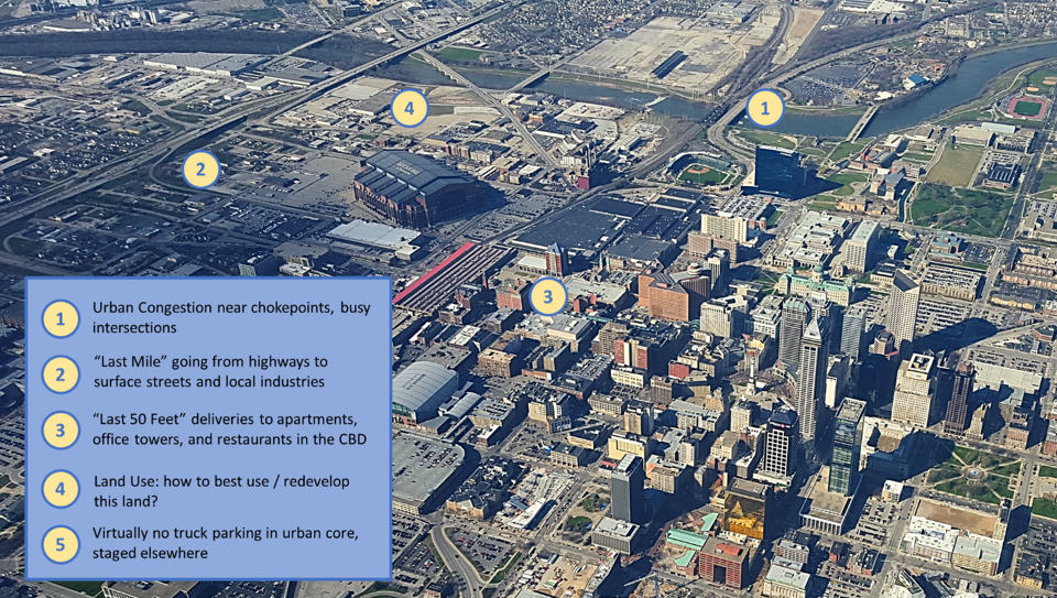
Source: CPCS
| Challenge | Crux of the Issue |
|---|---|
| Urban Congestion | Highway and street congestion delays freight shipments. Congestion could either be intersection/interchange congestion and mainline congestion on roads, or at natural or man-made chokepoints and barriers such as rivers or border crossings. |
| “Last Mile” Access | Truck movement between freight facilities and mainline transportation links can be inefficient. Queuing is caused by inefficient signalization, capacity constraints (including off-ramps), tight turns, circuitous routing (ingress, egress constraints), and incompatible corridor uses (e.g. bicycles lanes on freight corridor). The “last mile” is not a literal mile: in many areas, there may be 6 to 9 miles of arterial roads connecting freight facilities with free-flowing mainline transportation assets, like interstate highways. |
| “Final 50-feet” Access | Loading and unloading trucks can block lanes. Trucks often circle looking for space to load/park; both issues exacerbate traffic. The “final 50-feet” of a trip begins when the truck stops, and the driver must carry goods the remainder of the distance, often greater than a strict 50 feet. |
| Truck Parking | Shortage of truck parking indirectly affects mobility; lack of driver knowledge of available parking affects driver choices and behavior near freight facilities. |
| Land use | Land uses are often not synchronized with freight demand, resulting in additional freight VMT, congestion, circuity, emissions and noise pollution. |
Agencies have devised a number of techniques that involve data fusion – integrating both existing and new data sources – to address these challenges. The case studies illustrate these best practices and innovations.