• Skip to main content
  • Skip to primary sidebar

Understanding and Using New Data Sources to Address Urban and Metropolitan Freight Challenges

National Cooperative Freight Research Program (NCFRP) Project 49

  • Urban and Metropolitan Challenges
    • Congestion
    • Last-Mile Access
    • Final 50-feet Access
    • Land Use
    • Truck Parking
    • Case Studies
  • Emerging Data Sources
    • GNSS/GPS
    • Radar
    • Wireless Address Matching
    • Administrative Records
    • Cellular/GSM
    • Induction Loops
    • LIDAR
    • Computer Vision
  • Analytical Approaches
    • Speed
    • Location
    • Re-identification
    • Classification
  • Stewardship Principles
    • Transparency and Openness
    • Purpose Specification
    • Data Minimization
    • Data Quality and Accuracy
    • Accountability
    • Security
    • Data Management
  • Resources
    • Source Use Concept Map
    • Case Studies
    • Previous NCFRP Projects
    • Glossary
    • Sources Cited
Home » Emerging Data Sources Overview and Descriptions » Cellular/GSM

Cellular/GSM

What is the data source?
Cellular wireless communication (cellular) is a communication technology that allows for the wireless transmission of data and voice between mobile devices and other mobile devices, the internet, or other services across long distances. Data is transmitted between devices using various bands of the radio spectrum, depending on the particular technology and service provider. Locations are derived only when a cellular tower is accessed by a device (“device pings”), and are therefore less dense and have less locational precision than GPS/GNSS trace data. Also, cell data locates the cellular device, not the vehicle, which poses certain accuracy limitations. The various signals can be used to locate a mobile phone in time and space.
What challenges do the data address?
Cellular communications are a source of location data. Cellular O-D data are a measure of estimated device movements between pre-defined geographic areas/zones. The movements are developed based on analysis of mobile device sightings and activity locations over a set time period, ranging from weeks to months. Cellular-derived data’s ability to identify common origin and destination points can help planners determine where freight generators and receivers may be located, and the routes that trucks take between origin and destination. These data can be used to address congestion, first/last mile, and last 50 feet challenges in urban and metropolitan areas.
Why is it new?
New advances in lower cost cellular technology and high bandwidth networks such as 4th Generation Long Term Evolution (4G LTE), and now 5th Generation have made cellular-based communications all but ubiquitous. When cellular devices and their real-time data streams are correlated with the movement of vehicles, they take the form of both spatial and time series data.
How are the data captured?
Mobile phone positioning is required when a user communicates with the network (Chen et al, 2016). To date, cellular communication relies on base stations (cell towers) that provide coverage for a given area, or “cell.” These cells are arranged in clusters, and clusters are arranged adjacent to one another to provide almost continuous coverage (see figure). Because of this arrangement of cells, radio frequencies can be reused by the cells.
Base station or cell to cell clusters (GSMFavorites.com, 2017)

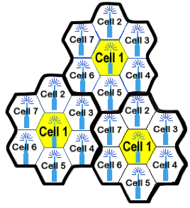
The cells are connected to several back-end systems that handle traffic, connect mobile devices together, and manage handoff of mobile devices from one cell to another (see figure). Communication between mobile devices and cells occurs through radio channels between the cell and the mobile device—one channel for mobile to cell communications and one for cell to mobile communications, enabling simultaneous two-way data transmission (Rappaport et al., 2000). Additional channels are used as control channels, to handle call requests, registering mobile devices with cells, etc.

Depiction of Cells Connected to the Cellular Switch and Public Switched Telephone Network (GSMFavorites.com, 2017)

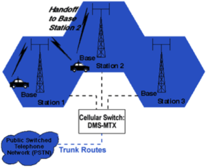
When a user initiates a network connection event (e.g. a voice-call), the cellular network operator needs to know his/her location in order to determine the cell tower used to channel this event (Chen, 2016). Thus, the positioning data (containing information on users’ locations) is generated when an event occurs. Such data is automatically and passively generated for cellular network operators’ own purposes, including billing information collection and network management. Device movements are tracked based on analysis of mobile device sightings and activity locations over a set time period, ranging from weeks to months.

What are policy considerations in its use?
A cell phone ping is when a signal is sent to a cell phone and the cell phone responds by reporting its location. In 2013, The FCC issued a declaratory ruling regarding the use of Customer Proprietary Network Information (CPNI) or location information from cell phone pings (Kulus, 2013). Government officials and privacy advocates are in agreement that there is no legal way to obtain cell phone location information without the customer’s permission and that the source for this information is from the carriers themselves.

Airsage, GA-based wireless information provider, is the only supplier of cellular location data. Airsage has agreements with one or more nationwide cellular device carriers, which allows it to access wireless signaling data with the legal stipulation that the raw, unprocessed data be protected and not shared. So Airsage data must ensure the anonymity of the data through its aggregation. All records are encrypted to anonymize specific individuals or mobile devices. Active pinging of cell devices or tablets is another source but it can only be used with a group of study participants who have agreed to allow themselves to be pinged in order to identify their location. Unlike GPS data, privacy protections are built into the access provisions of cellular data. Cellular data can only be procured at the aggregated level, while disaggregated GPS data can be procured.

What are institutional considerations in its use?
Typical issues associated with cell data may include institutional capacity and training necessary to analyze and interpret the data.

Agencies and organizations typically only need an acquisition/subscription agreement with a data aggregator and vendor to obtain the data. but they may need GIS, and databasing capabilities to analyze and visualize the data. Policy or planning decision making based on cellular data may have equity concerns. The percent of the population that is represented in Airsage’s data is dependent upon the penetration rates of the carriers with whom Airsage has agreements. Percents can vary across geographics with greater penetrations in urban areas and less penetrations in rural areas, especially rural areas with only one provider (Hard et al, 2016).

What are technical considerations in its use?
It is widely recognized that mobile phone data is not representative and multiple reasons contribute to this, including proximity of mobile phones, multiple mobile phones in a vehicle, and penetration rates that vary greatly by cell phone carriers (Chen et al 2016). The accuracy of mobile phone positioning is generally lower than that derived from GPS technology and is unproven as far as accurate speed measurements are concerned (BITRE, 2015). At any given location in a cellular network, there may be several cell towers whose radio signals reach a device. If these multiple cell towers have similar signal strengths, the connection of a device may hop between multiple towers even when the device is stationary. In this case, it may appear that the user travels for several kilometers in just a few seconds. This phenomenon is known as an oscillation in a cellular network with significant impacts on data accuracy. In addition, cellular positional data do not have enough precision to locate vehicles on a network; the data is only precise enough to be used in aggregated zones, such as Traffic Analysis Zones (TAZs). This may limit the data for use to aggregate O-D applications (i.e., urban density and activity patterns). The anonymity of cell data makes it difficult to use for commercial vehicles and accurate detection of vehicle type and use is a problem. Passively generated datasets, such as cell data, lack ground truth to be validated against. Probably due to this reason, only a few studies using passive data have addressed this to some extent. Given the increasing penetration of mobile devices among the population for the long-term, use of GSM (Global System for Mobile communications) as a data source is an extremely durable data source.

Primary Sidebar

  • GNSS/GPS
  • Radar
  • Wireless Address Matching
  • Administrative Records
  • Cellular/GSM
  • Induction Loops
  • LIDAR
  • Computer Vision
Assessment of Challenges in Data Use

These ratings are depicted using green, yellow, and red, where green indicates ease of use of the data source, yellow indicates some hindrance in use, and red indicates difficult to use.

Policy Considerations
Regulatory Environment
Ownership
Privacy
Institutional Considerations
Capacity
Stewardship
Equity
Technical Considerations
Completeness
Accuracy
Verifiability
Dynamism
Durability
Definitions – Policy, Institutional and Technical Challenges

Copyright 2019, National Academy of Sciences. All rights reserved.